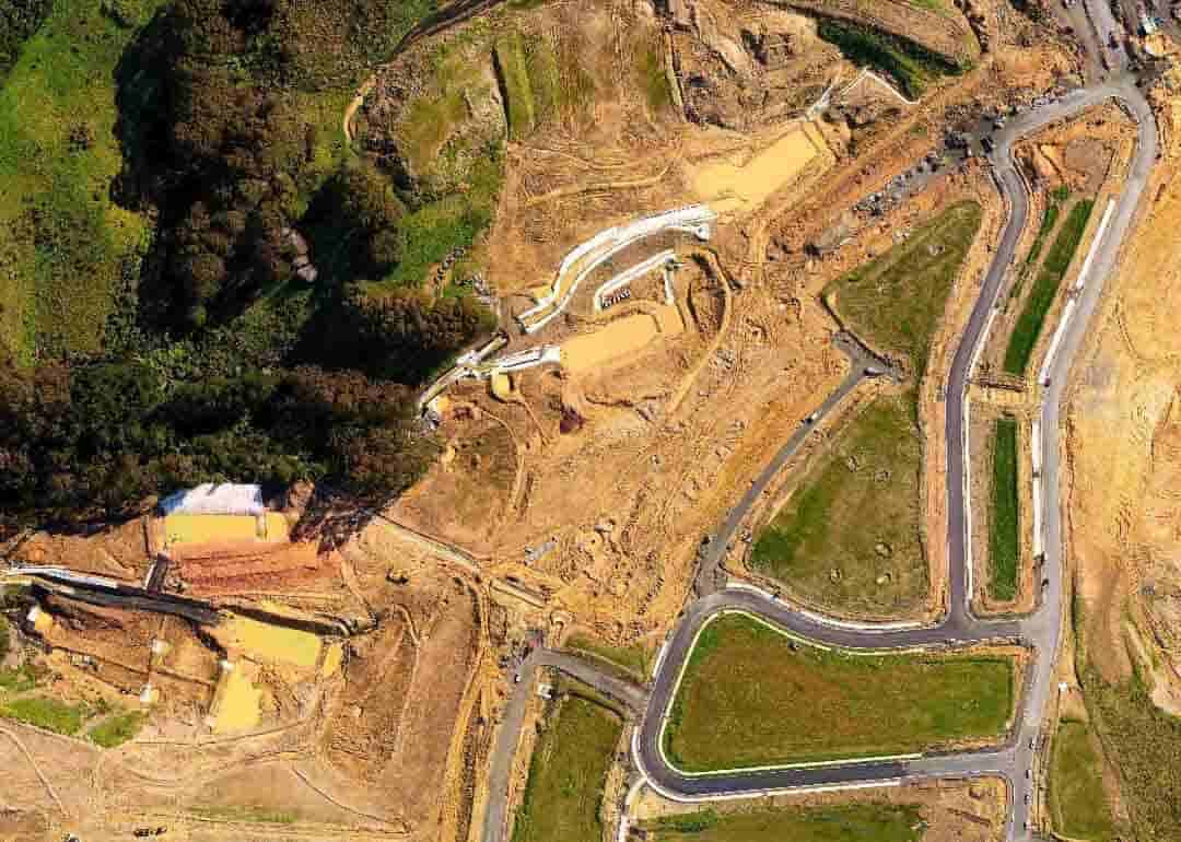
Orthomosaics
Our drones can produce 2D maps and 3D digital elevation models that enable you to fill in imaging gaps left by satellite mapping with up-to-date data.

Accurate data
Accurate maps are within grasp using high-res imagery taken by UAV and processed into large scale, pinpoint accurate maps.

Minimise cost & risk
Save nearly half the cost, while minimizing the timeline and risks presented to traditional surveying teams.
UASG SURVEY AND MAPPING
UASG Providing Drones and Satellite based Surveying, Mapping and GIS services. Our drones can reach even the most inaccessible, hazardous or large-scale sites using the latest UAV technology to provide a range of survey and mapping services. Our highly-experienced and accredited team can work faster and safely capture high-resolution imagery and survey-grade data to a sub centimeter accuracy level.
2D MAPPING
Drone surveying is a fast, accurate and cost-effective alternative to traditional surveying.
Modern drone technologies allow for the use of “geographic information system surveys” (GIS surveys) that capture, analyze, and correlate data gathered from multiple drones.
Our Aerial Mapping services can also be used for Digital Elevation Modelling (DEM) and Digital Surface Modeling (DSM) to construct accurate geospatial maps.
Our methods are far more efficient and cost-effective than older forms of surveying, as the safety risks involved are drastically reduced – less time in the field means data is processed faster and reports generated in a more efficient timeline that there’s less risk to surveying teams in steep or unstable areas.
3D MAPPING
UASG can provide an advanced interactive 3D model of your site, which can be used to perform accurate calculations, including measuring distance, area, and volume. These tools are ideal for Construction, Mining, Infrastructure Development and Agricultural purposes.
Drones provide a cost-effective, fast way of mapping build sites and existing facilities, while gathering geographical and topographical data in the form of photography, Lidar and video.
Surveys and inspections can be undertaken far more safely without compromising accuracy and 3D models that can be rotated over 360 degrees on all axis to achieve a unique point of view of the photographed buildings, artwork, structures, quarries, bridges, roads etc.

3D MAPPING
UASG can provide an advanced interactive 3D model of your site, which can be used to perform accurate calculations, including measuring distance, area, and volume. These tools are ideal for Construction, Mining, Infrastructure Development, and Agricultural purposes.
Drones provide a cost-effective, fast way of mapping build sites and existing facilities while gathering geographical and topographical data in the form of photography, Lidar, and video.
Surveys and inspections can be undertaken far more safely without compromising accuracy and 3D models that can be rotated over 360 degrees on all axis to achieve a unique point of view of the photographed buildings, artwork, structures, quarries, bridges, roads, etc.
VOLUMETRICS CALCULATION
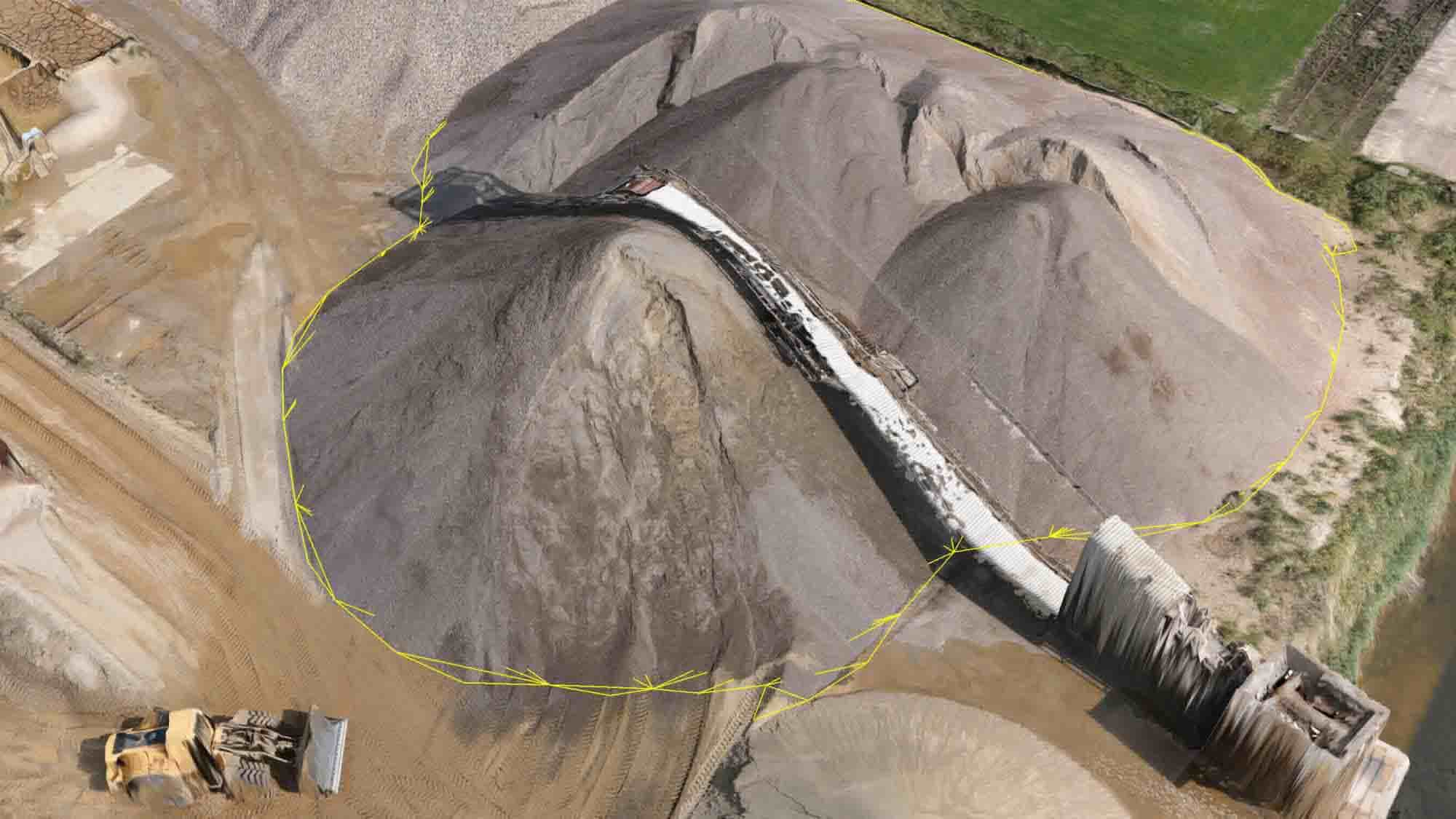
Calculating the amount of resources, such as coal, logs or iron ore, is much faster and more accurate with drones than with traditional methods performed using lasers or helicopters.
Using drones to measure stockpiles makes it easy to compare your current stockpile volumes to previous surveys in order to track site progress. You can also compare stockpile surveys to a final grade design file to calculate how much material you have left to add or remove.
With georeferenced images taken from a drone flying above your worksite, 3D visualization of your site with measurements accurate to 1/10ft (3cm).
Leveraging that level of accuracy, you can use a drone survey visualization platform to take a variety of measurements, including stockpile volumes.

VOLUMETRICS CALCULATION
Calculating the number of resources, such as coal, logs, or iron ore, is much faster and more accurate with drones than with traditional methods performed using lasers or helicopters.
Using drones to measure stockpiles makes it easy to compare your current stockpile volumes to previous surveys in order to track site progress. You can also compare stockpile surveys to a final grade design file to calculate how much material you have left to add or remove.
With geo-referenced images taken from a drone flying above your worksite, 3D visualization of your site with measurements accurate to 1/10ft (3cm).
Leveraging that level of accuracy, you can use a drone survey visualization platform to take a variety of measurements, including stockpile volumes.
Unlock Your Business Potential With Drone Technology

UASG are pioneers in the Pakistan UAV Industry with collective expertise of more than 40 years. A team of Unmanned Aerial Systems Specialists who consult & provide advanced Drones & commercial services to International standard in Pakistan.
ABOUT US
OUR SERVICES
GALLERY
MAPPING
SMART FARMING
WIND TURBINE
SOLAR INSPECTION
PILOT TRAINING
CONTACT US
